Mangapurua Track - Bridge to Nowhere
Overview
A magnificent trail through stunning scenery with a unique history. Most of this trail has a clay surface which is hard and fast when it's dry, but soft and sludgy when it's wet, making riding difficult, and is very tough on bikes. This is definitely a dry weather track only.
Need to Know
This trail becomes very difficult in wet conditions and is often closed in winter and after heavy rain. Always check track conditions and weather forecasts before attempting this trail.
Description
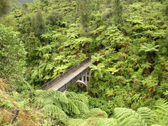
Starting from Ruatiti Road, the trail winds uphill for about 5km. Once at the top of the hill you have a few kilometers of relatively flat trail riding along a ridge. This will take you to the Mangapurua trig and the highest point of the trail (661m). From this high point, you'll get fantastic views of the Whanganui National Park and the Tongariro National Park. This is also where the Kaiwhakauka Trail meets the Mangapurua Trail. Spring water and toilets are available at this point. This is also a great spot for refuelling. All of the hard work is done now and you can enjoy an exciting long downhill passing through the stunning scenery of the Mangaparua valley, including battleship bluff and historical points of interest, ending up at the Bridge to Nowhere and then down to the Mangapurua landing and the Whanganui River where your jet boat or canoe wait for the trip out to Pipiriki. The trail is remote and the only way out are via the river or ride back up to Ruatiti.
In conjunction with local operators, you can arrange a transport service into the start of the track in the Ruatiti valley, and after being picked up by jet boat at the Mangaparua landing, you'll be jet boated down through the magnificent scenery of the Whanganui River to Pipiriki where you'll be picked up and transported back to your starting point.
In conjunction with local operators, you can arrange a transport service into the start of the track in the Ruatiti valley, and after being picked up by jet boat at the Mangaparua landing, you'll be jet boated down through the magnificent scenery of the Whanganui River to Pipiriki where you'll be picked up and transported back to your starting point.
History & Background
The Mangapurua Valley was opened by the government to encourage settlement by returning World War 1 soldiers and their families. The land was cleared of forest and turned into farmland but problems such as poor access, erosion and falling stock prices during the Depression years forced most of the settlers to abandon their farms. The few remaining farmers were forced to leave the valley in 1942 when the government refused to maintain the storm damaged road.